
Residents in Western Australia were prepared for Cyclone Errol to hit the Kimberley Coast on Friday.
The cyclone started as a Category 2 storm but lost strength before reaching the coast at 8 pm (10 pm AEST) just below Kuri Bay as a tropical low.
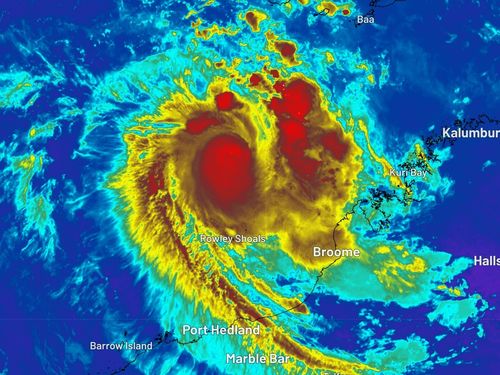
As it approached, the slow-moving system brought sustained winds of 45 km/h near the center, with gusts of up to 75 km/h when it landed 85 kilometers southeast of Kuri Bay and 175 kilometers northeast of Derby.
“Moderate to possibly heavy rainfall is expected to continue over the next several hours as the system tracks inland,” the Bureau of Meteorology (BoM) said.
The BoM also warned that locally intense rainfall about the north Kimberley coast over the next few hours could lead to “dangerous and life-threatening flash flooding”.
They predict six-hourly totals of 100-140mm are possible, and with isolated falls in thunderstorms in excess of 150mm.
Heavy rain for the remaining parts of the northern Kimberley over the next few hours could see six-hourly rainfall totals of 50-80mm, while isolated falls in thunderstorms in excess of 100mm.
Rainfall is expected to ease below warning thresholds by later on Saturday morning.
The areas which may be affected include Wyndham, Kalumburu and Troughton Island.