

ORLANDO, Fla. – The last couple of months have been a roller coaster in every sense of the analogy when it comes to the weather in Florida.
March brought with it weekend after weekend of strong thunderstorms, and even a few destructive tornadoes.
April turned the tides almost entirely, drying our state out while also increasing the risks of brush fires at a steady rate.
I suppose it seems fitting that Mother Nature decided to throw yet another wrench in the repetitions we’ve been building over the back end of April.
Now, the threat for powerful thunderstorms is in the forecast for some of us in the Central Florida peninsula.
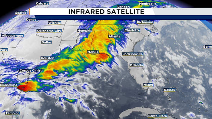
The recent storm system has made a significant impact by weakening the persistent ridging that dominated the weather in the latter part of April. This ridge was the main cause of the prolonged drought conditions that led to the browning of lawns across the region.
By observing the satellite images, it is evident that a trough and cold front are moving towards us at the surface. This weather pattern has already triggered a series of severe storms, including confirmed tornadoes.
Now, in our local area, we aren’t expecting a widespread instance of powerful storms or a bunch of tornadoes. So take a sigh of relief!
As a result of this incoming weather system, there will be a reinvigoration of our afternoon sea breeze. Residents in Marion, Sumter, Lake counties, as well as those along the east coast from Flagler to Brevard counties, should remain vigilant for the possibility of rapid, isolated spinups.
We’ll likely start to see rains settling in first thing Sunday morning for our western counties. Then, throughout the warmest portions of the afternoon, the front, combined with daytime heating, should keep lingering showers and storms across a majority of us.
Around sunset as the cold front approaches our eastern shoreline, some strong storms are possible for Flagler, Volusia, and especially Brevard counties.
Stay tuned for more as we breakdown all the latest data and get you geared up to tackle a return to heavy rains and lightning in your neighborhood.
Copyright 2025 by WKMG ClickOrlando – All rights reserved.