Road and rail disruptions are being experienced by commuters following a severe freeze in the UK overnight, with temperatures forecasted to plummet to -8C and the possibility of receiving up to 30cm of snow.
Temperatures could dip as low as -10C this weekend with weather warnings in place across much of England and Scotland for snow.
Reports initially showed that Rostherne in Cheshire and Yeovilton in Somerset recorded temperatures as low as -5C during the night. In Scotland, Eskdalemuir in Dumfries and Galloway also experienced the same freezing temperatures, dropping to -5C at 11pm on Thursday.
As the country wakes up this morning, weather warnings for ice remain in place in Scotland, northern England and western Wales.
Disruption is expected for commuters throughout the morning, with poor weather currently affecting National Rail’s Northern and ScotRail services.
National Rail is advising all travelers to verify the status of their train services before embarking on their journey, especially due to the additional challenge posed by scheduled significant maintenance works taking place throughout the rail network.
In Wales, buses are replacing trains between Llandudno Junction and Blaenau Ffestiniog.
It comes as the UK Health Security Agency (UKHSA) issued cold weather health alerts for all of England ahead of a week of low temperatures.
Amber alerts have been issued from 12pm on Thursday until January 8, meaning a rise in deaths, particularly among those aged 65 and over or with health conditions, is likely, the UKHSA said.

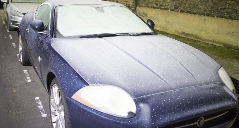
Freezing conditions in London left cars completely iced over as temperatures dipped to as low as -8C overnight

An overturned car is on its roof in the snow near Gartly on the A97 in Scotland on Thursday

Groundsmen had to clear snow from the football pitch for Thursday’s match between Aberdeen and Ross County


The above six Met Office maps show snowfall in London on Saturday between 5pm and 10pm
Temperatures had been expected to fall as low as -8C in rural Scotland and northern England on Thursday night.
The Met Office also forecast cold weather in parts of Wales and rural spots in southern England, with between -4C and -5C expected.
Dan Stroud, a meteorologist at the Met Office, said: ‘There’ll be widespread frost across the country (overnight), from Land’s End to John O’Groats.
‘It will be comfortably below where we should be for this time of year and I would expect temperatures to hit minus 8C in parts of Scotland.’
Mr Stroud confirmed conditions should become warmer by the end of this weekend before cold weather strikes again early next week.
He said: ‘The second half of the weekend should be in the high singles or low doubles.
‘But temperatures will dive again next week, particularly on Monday and Tuesday.
‘They should start to improve towards the latter end of the week. But there’s a lot of water to go under the bridge until then.’
A yellow weather warning indicates there could be icy surfaces in northern and western Scotland, the north-west of England and Northern Ireland this morning.

Snow in Allenheads, Northumberland, photographed on Thursday morning

A canal boat got wedged across the Bridgewater Canal on Thursday after an embankment collapsed due to heavy rain in Manchester


The above five Met Office maps show snow in London between Sunday 10pm and Monday 2am
It will remain in place until 10am on Friday morning, and could make for difficult travelling conditions, the forecaster warned.
A snow and ice warning is also in place covering parts of northern Scotland until 10am on Friday.
A yellow warning for snow is in place from noon on Saturday until 9am on Monday and covers all regions of England, other than the South West, the majority of Wales and parts of southern Scotland.
A separate yellow warning for snow only covers the majority of Scotland from midnight on Sunday until 12pm on Monday.
About 5cm of snow is expected widely across the Midlands, Wales and northern England, with as much as 20-30cm over high ground in Wales and the Pennines.
Strong winds could lead to snow drifts in some areas, and freezing rain as temperatures creep up could add to the risk of ice.
The Met Office has warned people to be prepared and aware when travelling with longer journey times likely.
Railways are likely to experience delays or cancellations, with National Rail confirming that various routes across England, Scotland and Wales are impacted.
Avanti West Coast and London Northwestern Railway services are disrupted between London Euston and Watford junction after a line fault – trains will be affected throughout rush hour until at least 9am.
There will be no GWR trains running between Liskeard and Looe until 11am due to a broken down train – the railway operator is currently putting in place rail replacement services.
A fault at a level crossing in Pencoed will also cause delays between Bridgend and Pontyclun until 12pm.

The Met Office has issued a snow warning between 12pm on Saturday and 9am on Monday

TODAY: Snow and ice warnings for Scotland, England and Northern Ireland

SATURDAY: A snow and ice alert for most of England and all of Wales begins at 12pm Saturday

SUNDAY: A snow warning begins for Scotland on Sunday, on top of the alert for England

MONDAY: The snow warning will still in place for Scotland until noon on Monday

The UK Health Security Agency imposed an amber cold health alert until January 8 which warns the weather will likely cause ‘significant impacts across health and social care services’


The NHS issued an urgent warning for people not to venture outside as the UK braces for three days of snowfall and a -10C ice blast this weekend.
Medics have warned vulnerable people to avoid going out early or late in the evening, to stock up on food and medications and take sensible precautions.
Even London could face two five-hour periods of snowfall, Met Office maps have suggested, after the capital was placed under a rare two-day weather warning.
Forecasters imposed an updated yellow snow alert this morning for most of England and all of Wales, running from noon on Saturday until 11.59pm on Sunday – having initially put out the warning until 9am on Monday when first announced yesterday.
Then NHS warned of the dangers of slips, trips and falls in the cold weather and asked people to avoid venturing out at night or early in the morning.
The NHS Black Country integrated care board warned: ‘Avoid going out early in the morning when frost is thick or late at night when it’s dark,’ it said, adding that people should wear shoes with good grip and keep their hands free to stabilise themselves.
In Herefordshire, the Wye Valley NHS Trust told people to ‘make sure you have sufficient food and medicine and take measures to reduce draughts in your home’. George Eliot Hospital NHS Trust, in Nuneaton, issued the same advice.
The NHS also advised people to check on vulnerable neighbours, friends and family to make sure they are okay.
It added that people should keep active by not sitting still for more than an hour and wearing several layers of thinner clothing.
Meteorologists say there is ‘considerable uncertainty’ over where and when the snow will fall, but the latest warning maps suggest London will see it over two periods.
The first could happen this Saturday evening between 5pm and 10pm, and then the second is set to be 24 hours later from 10pm on Sunday to 2am on Monday morning.
It comes as Mayor Sir Sadiq Khan activated London’s Severe Weather Emergency Protocol (SWEP) today to provide emergency accommodation for rough sleepers in London.
It is the first time the Met Office has issued a snow warning for Greater London in nearly two years since March 2023 – and only the 13th time over the past five years.
But there is still some doubt over whether snow will actually fall in London, given the Met Office app’s hour-by-hour forecast for the capital currently features no snow.
The last time any Met Office weather station reported snow on the ground in Greater London was December 12, 2022 when Northolt in West London had 1cm (0.4in).
But the weather service does not have many stations that report snow depth in London – and there have been incidences of light dustings of snow since that year.
The most recent was on November 19, 2024 with a dusting amid an Arctic chill that saw temperatures fall well below zero, trains cancelled and cars stuck in other parts of the country.
There was also some falling snow in London on March 8, 2023 when 4cm (1.6in) accumulated just outside the capital at Amersham in Buckinghamshire – although no snow accumulated at any of the London weather sites operated by the Met Office.
Snow also fell in London during lockdown on January 24, 2021, when people were seen sledging down a hill in Greenwich Park and making snowmen in Battersea Park.
Met Office meteorologist Tom Morgan said yesterday that the ‘very large’ snow warning for ‘doesn’t mean that everywhere within that warning could see snow – it’s just a heads-up there could be some impacts’.
He continued: ‘It’s definitely going to start off as snow in many places but it’s a question of how quickly that snow melts and turns back to rain, it’s more likely that the snow won’t last that long in southern England.
‘It’s quite likely the warning will be updated quite frequently between now and the weekend. Certainly if you’ve got travel plans on Sunday and perhaps Monday stay tuned into the forecast.’

Snow on the ground in the west end of Aberdeen on Thursday after a Met Office warning for the area

Snow on the railway line between Mallaig and Fort William in the Scottish Highlands

A Porsche has crashed off the A635 Wessenden Head Road above Holmfirth in West Yorkshire

Aberdeen has had snowfall in recent days, with the west end of the city photographedon Thursday

A Network Rail road-rail vehicle carries out checks on the snowy Mallaig line in Scotland

Snow on the ground in the west end of Aberdeen this morning amid severe weather in Scotland
Forecasters warned that rural communities could become cut off, schools could potentially be closed and there is a chance of power cuts and road closures as well as delays and cancellations to flights and trains.
Age UK director Caroline Abrahams said that the imminent cold snap will bring the Government’s decision to limit the winter fuel allowance to only the poorest pensioners ‘into sharp relief’.
Ms Abrahams told how the charity had already been contacted by older people ‘worrying about what to do when this moment arrived’.
‘We urge older people to do everything they can to stay warm, even if that means risking spending more on their heating than they feel they can afford,’ she said.
‘The energy companies are under an obligation to help if you are struggling and there may be support available from your local council too. Better that than to jeopardise your health.’
Wintry conditions have already caused disruption to road and rail travel in many parts of Scotland, with warnings of further inclement weather to come.
Yesterday there were no services on two railway lines in the Highlands after heavy rain caused landslips and flooding.
The Far North Line between Inverness and Wick was closed due to landslips at three sections of the route and flooding at Beauly.
Rail operator ScotRail said the line will be closed between Inverness and Dingwall until Saturday.
In a statement, ScotRail said: ‘We’re dealing with three landslips, between Lairg-Rogart, at Bunchrew near Inverness, and at Beauly. Flooding at Beauly has also closed the line.
‘We’ll share more information on the progress of repairs later.’
Rail replacement buses have been laid on, with ScotRail saying buses were due to depart Wick at 12.34pm and Inverness at 6.31pm.
But services are set to resume on the Highland Main Line after it was closed due to flooding caused by heavy rain in the Kingussie area.
The reopening of the line had been delayed while engineers waited for water levels in the Balavil Burn to fall to allow them to inspect a bridge, but Network Rail Scotland said this inspection had now been completed.
For those who intend to travel despite the current wintry weather, both the Met Office and National Rail issued alerts to remind Britons to plan ahead.
Difficult driving conditions should be expected, particularly within areas under a yellow weather warning. Allowing extra time is also advised, with delays, diversions, or hampered conditions likely for road users.
For those using public transport, passengers are advised to check any timetables and services before setting out in case of delays or cancellations due to inclement weather.

The Fire Brigade check on a car stranded in flood water yesterday morning in York city centre

The Bridgewater canal collapses, causing flooding at Dunham Massey in Cheshire

Pedestrians walk through snow at Rotherhithe in South East London on November 19, 2024

A snowy morning as commuters walk over London Bridge in the capital on March 8, 2023

A person skis in the snow at Greenwich Park in South East London on December 12, 2022

People making a snowman at Battersea Park in South West London on January 24, 2021

District Line trains pass near Kew Gardens in London during snow on December 10, 2017

Snow ploughs clear the ground at London Heathrow Airport on January 18, 2013

Skaters enjoy the snow at Somerset House ice rink in Central London on December 16, 2009

The scene on a street in Chiswick, West London, during heavy snowfall on February 2, 2009

Cyclists and pedestrians on Waterloo Bridge in London during snowfall on March 4, 2005

A snowman in front of the London Eye during severe weather in the capital on January 8, 2003
In Bristol, the Severe Weather Emergency Protocol has been activated by Bristol City Council and homeless charity St Mungo’s, which will run until January 8.
This will see increased outreach shifts and more accommodation made available, with the aim of ensuring nobody has to sleep on the streets during such extreme weather.
But in better news, a major incident declared in Greater Manchester on Wednesday because of flooding has been stood down, with emergency services and partners now focusing on recovery efforts.
There have been no casualties or reports of serious injuries.
