
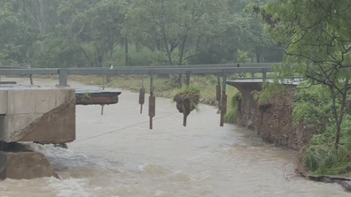
The upcoming Valentine’s Day gift from nature is predicted to bring winds with gusts over 200km/h and more than 500mm of rain, which could lead to flooding, potentially blocking major roads for about a week.
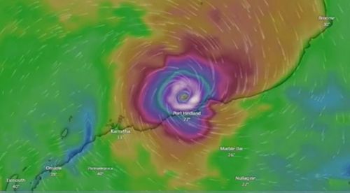
According to the Bureau of Meteorology’s state manager for Western Australia, James Ashley, the system is anticipated to shift slightly westward before continuing southward today.
“A real feature of this system is that it’s quite erratic and slow-moving off the Pilbara coast,” Ashley said.
The most intense rainfall is expected to start today and persist until tomorrow, originating from the eastern side of the system as Zelia nears and makes landfall.
It’s expected to dissipate quickly once it makes landfall, becoming a tropical low by Saturday.

Meteorologists also warned residents between Port Hedland and Bidyadanga of the potential of a dangerous storm tide as the cyclone centre crosses the coast.
“Tides are likely to rise significantly above the normal high-tide mark with damaging waves and dangerous flooding of some low-lying areas close to the shoreline,” the Bureau of Meteorology said.
Gales with damaging wind gusts of 120km/h are developing near the coastal fringe between De Grey and Wallal Downs.
ADF to build temporary bridge to give access to flood-ravaged town
This could extend along the coast between Bidyadanga and Dampier including Port Hedland and Karratha.
A number of flood warnings and watches were in place across the state, including the Pilbara Coastal Rivers, Onslow Coast, Fortescue River, Ashburton River and parts of Sandy Desert Catchments.