
Multiple parts of the country are bracing for heatwave conditions over the weekend with authorities warning people to plan ahead and stay informed.
The mini heatwave will largely impact parts of south-eastern Australia over the coming days in a short and sharp burst of hot weather.
Adelaide, Melbourne, and Sydney will experience temperatures approaching 40 degrees Celsius starting today until Sunday due to warm and dry north-easterly winds covering several states and territories.

Residents have been told to stay hydrated, keep cool, avoid the heat and check in on vulnerable people such the elderly and young children.
Communities have also been reminded to never leave children or pets in vehicles.
On Sunday, some parts of the western suburbs will bake in temperatures of 40 degrees.
Spare a thought for NRL players and fans as Parramatta host West Tigers, where the mercury is forecast to still be 37 degrees at the 4.05pm kick-off.
The encounter will likely feature additional drinks breaks to provide heat relief for players.
But by Tuesday, temperatures across Sydney will have fallen to a maximum of 24 degrees.
In Melbourne, the qualifying sessions for the Australian Grand Prix will occur at 4 pm tomorrow, coinciding with the forecasted peak temperature of 37 degrees along the city center street circuit.
Some outer Melbourne suburbs are heading for even hotter conditions, with the mercury peaking at a scorching 39 degrees in Tullamarine.
But Formula One fans can expect much cooler and wetter weather at 3pm on Sunday when the main race begins.
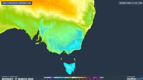
On Monday, residents will be waking to a top temperature of just 17 degrees, the coolest day of the year to date.
South Australia’s capital, Adelaide, will start experiencing rising temperatures today, with the peak expected to reach a scorching 38 degrees tomorrow.
In sharp contrast, the warmest it will get on Monday is just 21 degrees. Unfortunately for farmers hoping for rain, they’re forecast to receive falls of 5mm when the cold front rolls in.
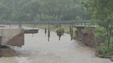
ADF to build temporary bridge to give access to flood-ravaged town
The national capital is perhaps the city where the change in conditions will be felt most.
Following a top temperature of 35 degrees tomorrow, the overnight lows from Monday will plunge to single digits, making for some cold mornings.
From Tuesday, sub-zero temperatures and frost are forecast for the NSW ski fields.
Conditions across the Apple Isle will also dramatically change from early next week.
Hobart residents can look forward to a very pleasant maximum of 28 degrees tomorrow before the cold front advances and the mercury nosedives to a top of 17 degrees by Monday.
Snow showers are also heading for parts of Tasmania above 1000m, including Mount Wellington above Hobart.
The approaching chillier weather comes ahead of the March equinox next Thursday, where we see equal hours of day and night.
This is followed by the end of daylight saving early next month in NSW, Victoria, South Australia, Tasmania, and the ACT.