

ORLANDO, Fla. – As we approach the official start of spring on the calendar, the weather across the United States is becoming increasingly unusual.
We are also witnessing interesting developments over the Pacific Ocean that are likely influencing the unusual weather patterns being experienced in Florida.
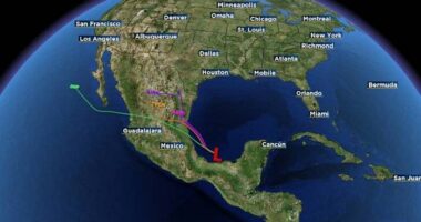
An area of low pressure is moving from the desert southwest towards the southern great plains, being influenced by two separate branches of the jet stream. It may come as a surprise, but the jet stream actually has various shapes and sizes!
The polar front jet is digging in from up north across the Rocky Mountains, while we also have a strong finger of the subtropical jet ripping across portions of Mexico, the southern half of Texas, and the upper Gulf coast line.
This is called a “shared energy region.” The two jets create their own organized area of very fast moving upper level winds that really help to drive up the intensification of showers, storms, and low pressure centers like we’re expecting tomorrow.
It’s very likely we’re seeing a stronger, more pronounced subtropical jet stream because of how much sudden warming we’ve seen in the equatorial Pacific. The ENSO regions closest to South America have already taken on El Nino characteristics. The 3.4 region pictured in the graphic below is approaching the neutral point between La Nina and El Nino. We’re bound to see some influence from this large dome of warmth expanding across the Pacific to our southwest.
Now let’s talk impacts.
During the first half of your Sunday, we anticipate a large majority of the rainfall will stay off our west coast until closer to the late afternoon, sunset time frame we start to see the stronger, more organized cells reach the upper one-third of the Florida peninsula. Overnight, rain chances will linger, and then after sunrise Monday morning we’ll start to see more of our central Florida viewing area at play. At least for the first half of the new day.
As we rock through very early Monday morning, between the hours of midnight and approximately 4 a.m., the center of the parent low pressure will start to dig in around the Steinhatchee/Perry, Florida area of the Big bend. An area synonymous with low pressure cyclones making landfall…
Monday we’ll see more organized showers and storms start to work their way through central Florida impacting the Orlando metro area around the lunch hour. We should be clear and good to go by about 3-4 p.m. at the very latest in the afternoon.
It will get windy, with sustained winds hanging out around 10-20 mph, and occasional gusts exceeding 30 mph in some spots.
The severe weather risk is confined to our northern Florida regions, trying to bleed down into Gainesville, maybe as far south as Ocala and further eastward towards Putnam, Flagler, and Volusia counties.
We can’t rule out even stronger winds within your organized thunderstorms, as well as a low-end risk for a spin up rogue funnel cloud or two.
We’ll be working hard here in the Pinpoint weather center tracking everything involved with this upcoming storm system ahead, so stick with us!
Copyright 2025 by WKMG ClickOrlando – All rights reserved.