Central Florida, get those layers ready to rock, and hold on to your hats.
We’ve been fairly cold in our area on a few different occasions after a front has swooped through. But this one is different.
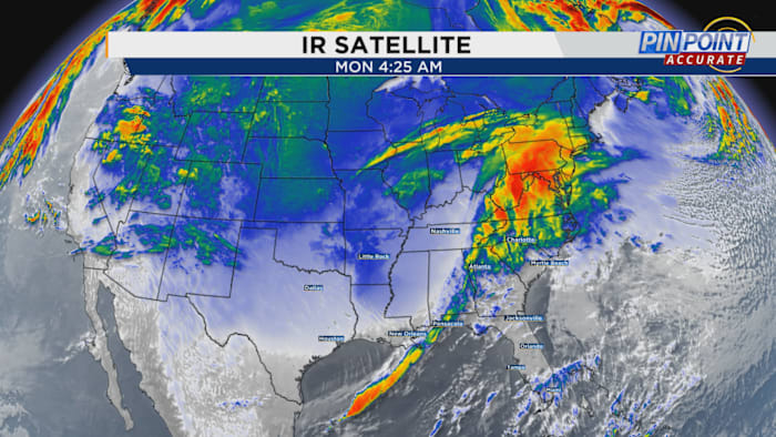
The latest storm has been actively pulling dense and chilly arctic air from Canada all the way down to the Gulf of Mexico coast and is now making its way towards Florida.
Some of us may receive some rain from the leading edge of the front as it pushes southeast.
The Storm Prediction Center has issued a level one, marginal risk for damaging straight line winds in some of the northwestern counties. Subsequently, temperatures are set to plummet significantly, resembling the drop experienced on a thrilling roller coaster ride at one of our popular amusement parks.
It will become apparent that the impending surge of cold air is distinct as it manifests effects on either side of the fast-moving blue front visible on your TV and phone screens. Monday will see swift strengthening of winds from the southwest due to the imminent temperature shift. Once the front passes through the region, these winds will rapidly shift to blow from the northwest.
Currently, you can see across the nation where that arctic air is. The temperature gradient is truthfully extreme over the Southeast right now.
Take a look at the difference between temperatures in northern Florida versus folks who have already felt the whiplash of the cold boundary in northern Alabama and Georgia. Nearly 40 degrees worth of a temperature drop!
I want to hammer home the wind speeds as well. Since we are dealing with a very thick and heavy mass of cold air, the movement of it alone is enough to pick up winds where we feel them at ground level. Arctic air is very shallow. If you envision you’re looking at the atmosphere in a 3D perspective, it comes in with a very shallow slope like molten lava flowing from a Hawaiian volcano.
We know Florida is generally mild and humid during the winter; on average we’re starting the day in the upper 50s to low 60s and maybe warming to the mid- to upper 70s on your general Florida afternoon.
If you hearken back to your physics class in school, that’s what helps amp our wind speeds up so significantly. The dome of coldest air will literally shove the warmth out of the way and quickly raise pressures. This is why wind chill will be a big piece of battling through this winter onslaught throughout the week.
Despite what you may have heard on social media, temperatures will not be dropping to record-breaking levels after all this is said and done.
But, if you combine morning lows of 30-35 degrees with wind speeds of around 15-20 mph, to the skin it WILL indeed feel as cold as upper teens to lower 20s for much of us in the viewing area.
You will need to bundle up, and tack on as many comfortable layers of clothing as possible.
Make sure your children are ready if they catch the bus. The winds could cause wind burn as well given the cold temperatures being pushed around by the gusty conditions. Bring your animals inside, cover your plants and above all DOUBLE DOWN on your vitamins, minerals and rest.
These drastic swings in temperature we’re likely to face over the next two weeks can really do a number on your immune system. We can’t let ourselves fall apart as the temperatures fall around us.
Do what you can to stay rested, hydrated, and healthy! It’ll be summer in central Florida again before we know it.
Copyright 2025 by WKMG ClickOrlando – All rights reserved.


