
There’s also a Severe Thunderstorm Watch for most of Northeast Ohio in effect until 7 p.m.
CLEVELAND — More severe weather is heading through Northeast Ohio!
The National Weather Service has issued a Severe Thunderstorm Warning for the following locations until 3:30 p.m.:
- Southeastern Richland County
- Southeastern Ashland County
- Southwestern Wayne County
- Western Holmes County
The NWS reports that at 2:42 p.m., a severe thunderstorm was located nine miles southeast of Bellville, or 12 miles northeast of Mount Vernon, moving east at 35 mph. The storm may produce 60 mph wind gusts with quarter size hail. Minor damage to vehicles, plus damage to trees and power lines, is possible.
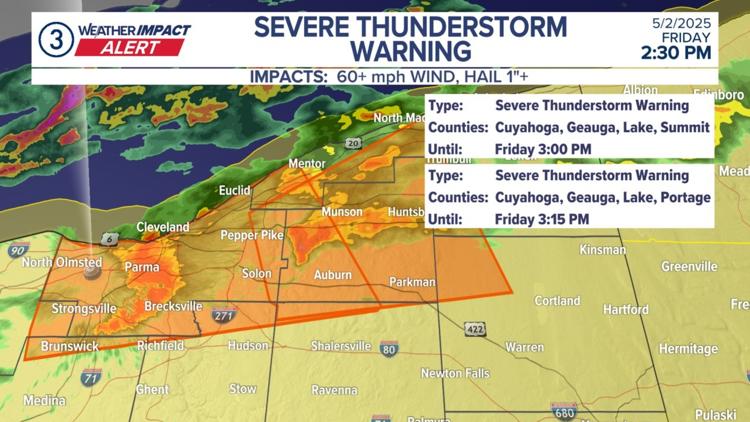
The following areas are under a Severe Thunderstorm Warning until 3:15 p.m., according to the National Weather Service:
- Northwestern Trumbull County
- Northwestern Portage County
- Geauga County
- East central Cuyahoga County
- Central Lake County
- Southwestern Ashtabula County
At 2:36 p.m., a severe thunderstorm was located over Chesterland, or nine miles southwest of Chardon, moving east at 35 mph. The storm may produce 60 mph wind gusts with quarter size hail. Minor damage to vehicles, plus damage to trees and power lines, is possible.
Amid the high winds, FirstEnergy reports that 3,715 customers are without power in Cuyahoga County as of 3 p.m.
The National Weather Service has also issued a Severe Thunderstorm Watch for most of Northeast Ohio until 7 p.m. this evening.
- Ashland
- Ashtabula
- Carroll
- Cuyahoga
- Geauga
- Holmes
- Huron
- Lake
- Lorain
- Portage
- Richland
- Stark
- Summit
- Tuscarawas
- Wayne
The notable county in Northeast Ohio not covered by the Severe Thunderstorm Watch is Erie County.
“Our first round of rainfall will come from pop-up showers and storms today,” explained 3News Senior Meteorologist Matt Wintz. “We’ll start dry — but as we begin to heat up, storms will pop on radar much like yesterday. Our severe threat isn’t as high as yesterday, but we’ll have to watch for a few stronger storms, especially the further south you’re located. Temps will push into the 70s with a little help from the sun.”
What about this weekend? Wintz says to keep the umbrella handy!
“We’ll have waves of rain at times as a low pressure swirls right over northern Ohio. Temps will turn noticeably cooler Saturday with 50s likely all day. We’ll remain rainy at times on Sunday as this low continues to swirl. Rain chances will linger Monday and Tuesday as well before we begin to clear out on Wednesday,” he added.