

ORLANDO, Fla. – Twelve days into the season and not a tropical feature was stirring. All was quiet across the Atlantic basin.
There is a potential for change as we are closely monitoring a signal in the western Gulf that seems to be gaining strength. However, there is no immediate threat to the state of Florida.
In its history, Tropical Storm Andrea has affected the state on several occasions since it was first included in the cycle of named storms for the hurricane season.
The name Andrea has appeared on our list of storms since 1950. Over the years, it has made landfall in our state twice as the inaugural named storm of the hurricane season. On both occasions, the storm’s arrival was typical of the early Atlantic season – disorganized and carrying heavy rainfall.
Tropical Storm and Subtropical Storm Andrea took aim at the state of Florida on two separate occasions, one time in 2007 and another in 2013 in its true tropical form.
Both were nasty rain makers and caused tremendous flooding to the different regions of the state they affected. Andrea through the years has never reached hurricane status, nor were there any instances of it being considered for retirement.
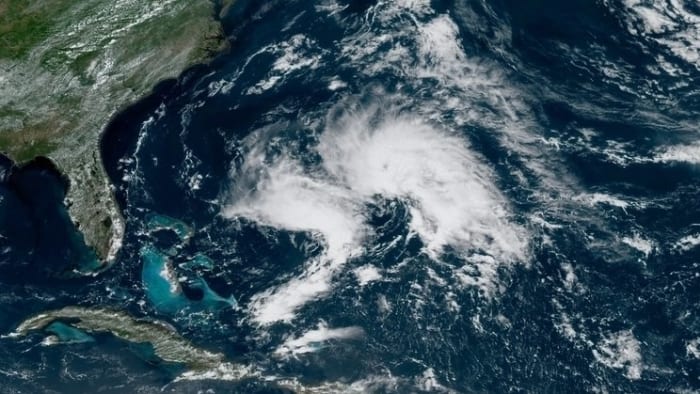
There was a pre-season variant of Andrea, witnessed in 2019. This one did influence our weather, positioning itself off our east coast. But inevitably washed out fairly quickly, as you can see in the satellite image above. If you didn’t know what you were looking at, you may not even consider this a cyclone of any kind.
Traditionally early tropical features that may attempt to develop in the month of June are more broad, and not as “visually appealing” on a satellite imagery. They don’t usually appear very symmetrical, and things like dry air or wind shear, maybe even a combination of both will take their toll on them.
It’s far and few between that we see an early season storm retired. Beryl, the anomaly that it was, happened to do just that last hurricane season.
Perhaps that’s also some of the psychology that goes into this ongoing hurricane season. Beryl came out of left field and defied several odds across the tropics. Will that happen again this year? If it does, does that mean it will be a potential repeat of what we experienced a little under a year prior?
The immediate answer is no. While it’s always a possibility we see another record setting storm at any point in the season, they serve no correlation or as an indicator for what else lies ahead. 2024 also taught us that fateful lesson.
Expect the unexpected. Prepare for anything.
[Check out a breakdown of Colorado State University’s latest forecast for the 2025 hurricane season]
Copyright 2025 by WKMG ClickOrlando – All rights reserved.