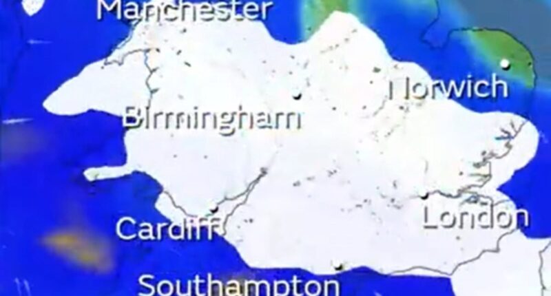
This weekend, according to Met Office maps, London might experience two five-hour periods of snowfall following a rare three-day weather warning.
The yellow alert covers almost all of England and Wales, as well as parts of Scotland, starting from noon on Saturday until 9 am on Monday, as announced by forecasters.
Meteorologists have highlighted the uncertainty regarding the exact locations and timings of the snowfall, although the most recent warning maps indicate that London might witness snow during two separate periods.
The first could happen this Saturday evening between 5pm and 10pm, and then the second is set to be 24 hours later from 10pm on Sunday to 2am on Monday morning.
It comes as Mayor Sir Sadiq Khan activated London’s Severe Weather Emergency Protocol (SWEP) today to provide emergency accommodation for rough sleepers.
And Government officials at the UK Health Security Agency imposed a six-day amber cold health alert for all of England from today until January 8 which warns the weather will likely cause ‘significant impacts across health and social care services’.
This includes a ‘rise in deaths, particularly among those aged 65 and over or with health conditions – we may also see impacts on younger age groups’ amid a ‘likely increase in demand for health services’ and ‘more risk to vulnerable people’.
While the amount of snow set to fall in London has not been confirmed, about 2in (5cm) is expected widely across the Midlands, Wales and northern England.
The warning is set to be updated before the weekend, but the highest totals of up to 30cm (1ft) are currently anticipated over high ground in Wales and the Pennines.
This is the first time the Met Office has issued a snow warning for Greater London for nearly two years since March 2023 – and only the 13th time over the past five years.
But there is still some doubt over whether snow will actually fall in London, given the Met Office app’s hour-by-hour forecast for the capital currently features no snow.


The above six Met Office maps show snowfall in London on Saturday between 5pm and 10pm


The above five Met Office maps show snow in London between Sunday 10pm and Monday 2am
The last time any Met Office weather station reported snow on the ground in Greater London was December 12, 2022 when Northolt in West London had 1cm (0.4in).
But the weather service does not have many stations that report snow depth in London – and there have been incidences of light dustings of snow since that year.
The most recent was in November 19, 2024 with a dusting amid an Arctic chill that saw temperatures fall well below zero, trains cancelled and cars stuck in other parts of the country.
There was also some falling snow in London on March 8, 2023 when 4cm (1.6in) accumulated just outside the capital at Amersham in Buckinghamshire – although no snow accumulated at any of the London weather sites operated by the Met Office.
Snow also fell in London during lockdown on January 24, 2021, when people were seen sledging down a hill in Greenwich Park and making snowmen in Battersea Park.
Met Office meteorologist Tom Morgan said: ‘At the moment we’ve issued a very large snow warning for Saturday until Monday but it doesn’t mean that everywhere within that warning could see snow, it’s just a heads-up there could be some impacts.
‘It’s definitely going to start off as snow in many places but it’s a question of how quickly that snow melts and turns back to rain, it’s more likely that the snow won’t last that long in southern England.
‘It’s quite likely the warning will be updated quite frequently between now and the weekend. Certainly if you’ve got travel plans on Sunday and perhaps Monday stay tuned into the forecast.’

The Met Office has issued a snow warning between 12pm on Saturday and 9am on Monday


The yellow warning for this weekend covers all regions of England other than the South West, the majority of Wales and parts of southern Scotland.
Forecasters warned that rural communities could become cut off, schools could potentially be closed and there is a chance of power cuts and road closures as well as delays and cancellations to flights and trains.
Senior Met Office meteorologist Marco Petagna said he expected ‘further snow and ice warnings’ to be issued tomorrow, with ice expected to pose a continued risk to motorists.
After a stormy New Year’s Day yesterday, temperatures began falling early this morning with a low of -8C (17F) in the Scottish Highlands and -7C (19F) at Shap in Cumbria.
Tomorrow morning could bring even colder temperatures of -10C (14F) in snow-covered parts of Scotland as well as -4C (25F) in London.
A yellow ice warning was in force for much of the UK this morning – indicating there could be difficult travel conditions across Scotland, Northern Ireland and North Wales, stretching down to the Midlands until 10am today.
A snow and ice warning was also in place covering northern Scotland until 10am today, as rain turning to snow was likely to bring travel disruption and difficult driving conditions.
For those who intend to travel despite the current wintry weather, both the Met Office and National Rail issued alerts to remind Britons to plan ahead if on the move today.
Difficult driving conditions should be expected, particularly within areas under a yellow weather warning. Allowing extra time is also advised, with delays, diversions, or hampered conditions likely for road users.
For those using public transport, passengers are advised to check any timetables and services before setting out in case of delays or cancellations due to inclement weather.
As per National Rail, the poor weather will impact trains running across Great Britain, with Northern services, TransPennine Express services, Transport for Wales services and ScotRail services all impacted.
Two new flood alerts were issued just prior to 6am today, with river levels peaking for both the Lower River Wharfe system in Yorkshire and Lower River Ure waterway in North Yorkshire.
The peaked water levels mean both the Wharfe and Ure river systems and surrounding tributaries are at risk of flooding.
Areas most at risk within the Lower River Ure system include low-lying land including agricultural land and local roads in the areas around Masham, Boroughbridge, Aldborough and Bishop Monkton.
For Lower River Wharfe, areas at risk of flooding span from Otley to upstream of Ulleskelf, including Tadcaster.

Snow on the ground in the west end of Aberdeen today after a Met Office warning for the area

Snow on the railway line between Mallaig and Fort William in the Scottish Highlands today

Aberdeen has had snowfall in recent days, with the west end of the city photographed today

A Network Rail road-rail vehicle carries out checks on the snowy Mallaig line in Scotland today

Snow on the ground in the west end of Aberdeen this morning amid severe weather in Scotland

The Fire Brigade check on a car stranded in flood water this morning in York city centre

Stormy weather and torrential rain during the New Year’s Day Parade in London yesterday

The Bridgewater canal collapses, causing flooding at Dunham Massey in Cheshire yesterday
No further significant rainfall is expected for today in the area, with water levels expected to begin falling in the coming hours.
Britons in the area are advised to avoid using low-lying footpaths, or any bridges near local watercourses, and to not attempt to walk, drive or cycle through flood waters, with officials advising that if the area is flooded, then forget it.
It comes after a major incident was declared in Greater Manchester yesterday after flooding forced homes to be evacuated and closed train lines and roads following heavy rain.
Greater Manchester Police said the major incident had been declared as mountain rescue teams were deployed to help Greater Manchester Fire and Rescue Service deal with damaged properties and stranded vehicles.
The police force added that the affected areas still under monitoring were Didsbury, Stockport, Trafford and Wigan.
Around 450 people were evacuated yesterday evening from a Didsbury hotel while 400 homes were at a lower risk with no widespread evacuation needed, police said.
Residents were also evacuated from a block of flats in Meadow Mill, Stockport.

Pedestrians walk through snow at Rotherhithe in South East London on November 19, 2024

A snowy morning as commuters walk over London Bridge in the capital on March 8, 2023

A person skis in the snow at Greenwich Park in South East London on December 12, 2022

People making a snowman at Battersea Park in South West London on January 24, 2021

District Line trains pass near Kew Gardens in London during snow on December 10, 2017

Snow ploughs clear the ground at London Heathrow Airport on January 18, 2013

Skaters enjoy the snow at Somerset House ice rink in Central London on December 16, 2009

The scene on a street in Chiswick, West London, during heavy snowfall on February 2, 2009

Cyclists and pedestrians on Waterloo Bridge in London during snowfall on March 4, 2005

A snowman in front of the London Eye during severe weather in the capital on January 8, 2003
The North West and Wales saw heavy rain on Wednesday, with Marsden seeing 101.2mm of rainfall, more than West Yorkshire’s January monthly average of 85.1mm, and Capel Curig in Wales measuring 101.2mm, which is less than a third of the monthly average of 327mm.
A number of train routes were disrupted or blocked by flooding on Wednesday, mainly in the North West of England, with some Northern services, TransPennine Express services, Transport for Wales services, and South Western Railway services affected.
National Highways said a section of the A628 Woodhead Pass between Woolley Bridge and Flouch was closed due to flooding, as was the westbound M56 between Junction 6 for Manchester Airport and Junction 8 for Bowdon.
In Bristol, the Severe Weather Emergency Protocol has been activated by Bristol City Council and homeless charity St Mungo’s, which will run until January 8.
This will see increased outreach shifts and more accommodation made available, with the aim of ensuring nobody has to sleep on the streets during such extreme weather.


