
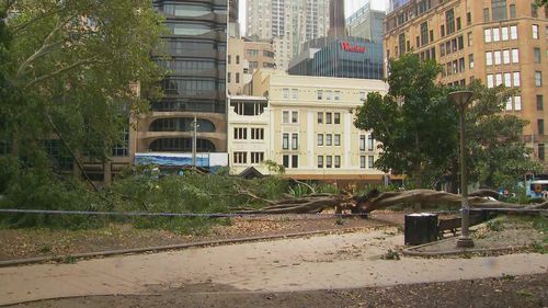
Two people have been injured after strong winds knocked over a tree in Sydney’s Hyde Park as wild weather lashes the city.
The tree came down at the park on Elizabeth Street and Market Street in Sydney’s CBD, near St James train station.
Two people are being treated for minor injuries.
Damaging winds have already started hitting the state, stretching from Kempsey to Southern Sydney.
Wind gusts have already hit 72km/h in Newcastle at 10am, while Sydney airport and Kurnell were lashed with 91km/h winds at 9.50am.
At Wattamolla, in the Royal National Park, wind gusts hit a peak of 106km/h by 10am.
Severe thunderstorms are set to combine with a low-pressure weather system over the east coast and bring significant rain through to Sunday.
Todays residents should anticipate continued strong winds, with speeds ranging from 55km/h to 65 km/h on average, potentially reaching up to 90km/h in exposed coastal regions.
Gusts are expected to increase during this morning, peaking in the afternoon, before they ease this evening.
Additionally, a significant portion of NSW is likely to experience heavy rainfall today, along with the possibility of flash flooding, particularly in the northern Hunter and Mid-North Coast areas later in the day.
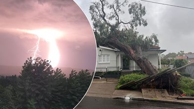
Wild storms rip up trees as tens of thousands in NSW still without power
The NSW SES has issued a watch and act warning for severe storms in northern NSW as rainfall totals of up to 200mm in a 48-hour period are expected.
According to NSW SES Commissioner Mike Wassing, the region stretching from Port Stephens to South West Rocks, as well as the far north-eastern part of the state, is expected to bear the brunt of the most severe weather conditions over the next 48 hours.
“People should prepare themselves now, know their risks and never drive, walk, ride or play in flash flooding should they come across a flooded road or causeway.”
Beachgoers are being warned of damaging surf conditions in coastal areas between the Illawarra and the Mid-North Coast.
In Queensland, severe storms are forecast today for the Burdekin and much of the Central Coast and Whitsundays, with the bureau warning of large hail and damaging winds.
Possible storms are also forecast for most of northern, and parts of central and south-east Queensland over coming hours.
Hails earlier this week smashed the Gold Coast and 25,006 properties lost power in the state’s south-east.